Irene Recap: How Good Were the Forecasts?
So, how did the meteorological profession do with Irene, a rare hurricane that made landfall in the Northeast United States? Meteorologists almost always do postmortems on major storms because we need to learn from our mistakes so we can do it better next time.
The intensity was overforecast at this point. We were forecasting a category 3 and it was a cat 2 when it made landfall.
Tuesday at 7:19am (roughly four days before landfall), the point of landfall in North Carolina, while slightly far west, was extraordinarily good for four days out. There was still an over forecast by one category but that isn't bad at all given it is four days out.
Why did the forecast improve? Because the National Weather Service started launching weather balloons at six-hour intervals and NWS and USAF hurricane hunter and high-level aircraft began gathering special data to load into the computer forecast models.
Shortly after 10pm, Iforecast posted the first of a series of genuinely amazing path forecasts.
Things didn't change much on Wednesday. I wouldn't change very much of what I posted on Tuesday and Wednesday.
Thursday at noon I posted the two sets of forecasts I'm not proud of. Titled, This Looks Serious, and, Irene: My Concern is Rising, I walked readers through some of the newer computer models that were taking the intensity of Irene up to, perhaps, a category 4. If this had occurred, the results would have been devastating. Irene did intensify aloft but for scientifically unknown reasons the intensification never made it to the ground. Meteorologists just do not have a solid understanding of the processes which cause tropical systems to intensify or weaken.
Throughout the week, I warned of extensive power failures due to toppled trees from wind and wet ground. I posted the map below of forecast rainfall which I predicted would lead to "major flooding."
Below is the rainfall map from Irene. Unfortunately, the colors are not the same but I believe you'll agree that 3-4 days out (depending on location), the correlation between the forecast and actual is remarkable.
From this point on, the path, wind, and rainfall forecasts underwent little revision as confidence went up (i.e., the boundary of the "confidence interval" narrowed).
So, how would I rate the quality of the forecasts presented on this blog?
By definition, it is difficult to forecast rare events because of the lack of analogues. For example, if there has never been a full-fledged hurricane in Manhattan in the era of skyscrapers, how will we know the level of damage a hurricane might cause?
So, with that in mind, let’s go over some of the forecasts made on this blog and compare them to reality. My colleagues at AccuWeather and I made some excellent proprietary forecasts that were sometimes ahead of those available from government sources, which is what our business clients pay for. However, because I do not post those forecasts on this blog, I'm doing an analysis of the public forecasts I posted here.
The early forecasts of Irene, made last Sunday (21st) were not very good. They took the storm toward Florida and had the intensity too low. On the other hand, the title of that posting was “Why We Can’t Get Too Confident on Hurricane Paths 5-Days (or Longer) Out.”
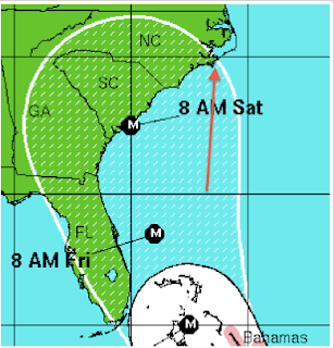
The first forecast in which I expressed confidence was titled, “This Looks Correct to Me: Irene’s Path.” I wrote, The eye (which is what is being forecast, not the geographic extent of the storm) could make landfall anywhere in the stippled area.
 |
| Arrow indicates the point of landfall as determined by the National Hurricane Center. |
The intensity was overforecast at this point. We were forecasting a category 3 and it was a cat 2 when it made landfall.
Tuesday at 7:19am (roughly four days before landfall), the point of landfall in North Carolina, while slightly far west, was extraordinarily good for four days out. There was still an over forecast by one category but that isn't bad at all given it is four days out.
Why did the forecast improve? Because the National Weather Service started launching weather balloons at six-hour intervals and NWS and USAF hurricane hunter and high-level aircraft began gathering special data to load into the computer forecast models.
Shortly after 10pm, I
Things didn't change much on Wednesday. I wouldn't change very much of what I posted on Tuesday and Wednesday.
Thursday at noon I posted the two sets of forecasts I'm not proud of. Titled, This Looks Serious, and, Irene: My Concern is Rising, I walked readers through some of the newer computer models that were taking the intensity of Irene up to, perhaps, a category 4. If this had occurred, the results would have been devastating. Irene did intensify aloft but for scientifically unknown reasons the intensification never made it to the ground. Meteorologists just do not have a solid understanding of the processes which cause tropical systems to intensify or weaken.
Throughout the week, I warned of extensive power failures due to toppled trees from wind and wet ground. I posted the map below of forecast rainfall which I predicted would lead to "major flooding."
Below is the rainfall map from Irene. Unfortunately, the colors are not the same but I believe you'll agree that 3-4 days out (depending on location), the correlation between the forecast and actual is remarkable.
From this point on, the path, wind, and rainfall forecasts underwent little revision as confidence went up (i.e., the boundary of the "confidence interval" narrowed).
So, how would I rate the quality of the forecasts presented on this blog?
- Path, 5 days to landfall and later: A+
- Intensity: C-
- Forecast of Widespread Power Failures: A
- Forecast of "Major Flooding:" A+
- Forecast of Window Breakage in Manhattan High-Rises: F
Please take a look at this posting and feel free to offer comments.
Tropical depression Twelve may give us some problems next week. There are areas of disturbed weather from Florida to South America that bear watching. We are only about halfway through hurricane season. I suspect Irene will not be the only hurricane we will deal with this year.
Thanks for reading.
ADDITION: Here is another take on the accuracy of the forecast. And, the New York Times has a good article about the weakening that took Irene from the 2 we forecast just southwest of NYC down to the borderline 1 it actually was.
Interactive map of Irene's path and damage. Total "customers" (homes and businesses) that lost power are 5.8 million. The electric utility industry uses 3.5 people per "customer" so the total number of people without power is just over 20,000,000.
UPDATE 6:50PM: My friend, meteorologist Dr. Cliff Mass, has a completely different take. He does not believe Irene was even a hurricane north of the North Carolina border. As I understand NHC's reasoning (and I may be incorrect), there were very high winds aloft and over water and they were concerned those would sustain the hurricane.
I present all of this because I want non-meteorologists to understand the complexities of what we are dealing with when it comes to hurricanes and tropical storms.


I don't claim to be a tropical expert, but I was skeptical of the intensity forecasts from the beginning. I based this strictly on the water vapor imagery, which showed a rather deep upstream mid-latitude trough (suggesting significantly greater shear to the north) and a LOT of dry air (unfavorable entrainment). Oversimplified? Perhaps, but sometimes we can get lost in the details.
ReplyDeleteI don't think the supplemental obs were the only reason that forecast accuracy improved. Steering flow became stronger with time, which helped to narrow the cone of uncertainty. Also, with increasing latitude comes a greater number of upstream raob sites - regardless of observation frequency.
Excellent blog. Thanks for listening.
TJ,
ReplyDeleteThank you for the comment.
Mike
Good article - but "We were forecasting a category 3 and it was a cat 2 when it made landfall. "
ReplyDeleteI saw no evidence of Cat 2 winds at landfall - what did you find?
Hi Rob,
ReplyDeleteAccuWeather has what appears to be a reliable surface measurement of 115 mph.
Mike
Rob,
ReplyDeleteAbove measurement was in NC.
MS
Sustained?
ReplyDeleteRob,
ReplyDeleteThat's what Jesse said.
Mike
I? You wrote those NHC forecasts yourself?
ReplyDelete@9:06am. In one case you are correct. I wrote "forecast" above when I meant "posted." That has been crossed out and corrected (I cross out errors so readers can readily find corrections). Thank you.
ReplyDeleteIn the other cases, I meant "I."
Keeping in mind this is a recap, if you go back to the real time posting of the forecast, you'll see the forecasting agency (e.g., NHC) is credited (with one exception where I inadvertently left it off). For example, if you look at the originally posted real time graphic above ( http://meteorologicalmusings.blogspot.com/2011/08/irene-getting-better-organized.html ) you see both the NWS and NOAA logos.
There were a number of possible forecasts from which to chose: NHC, ECMWF, GFS, etc. So, the one I posted is the one "I" chose at the time as the forecast I thought would be most correct.