
So How Did that Drought Forecast Work Out?
As a meteorologist, I have to be concerned about the quality of my forecasts. I always want to know whether they are correct.
On November 11, I posted a piece called Dagger in the Drought? where I forecast significant drought relief to the southern Plains between then and Thanksgiving. Since no rain is forecast in the region of interest tomorrow, we can go ahead the validate that forecast.
Here is the map I presented on the eleventh:
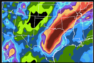

And, below here is the actual rainfall from the 11th to today:
The forecast rainfall between the DFW Metroplex south to I-10 between Houston and San Antonio is too high. Elsewhere, the forecast is quite good (considering it is a 13-day forecast) right down to the dry area from western Kansas into northeast New Mexico.
The purple on the lower map represents areas where 10 inches or more fell. Those areas were entirely within the European model's forecast area of 5 inches or more. Remarkable!
When I made the forecast, I was expecting a third storm on Thanksgiving day. Turns out the models were about 24-30 hours too fast. It will move across the Plains during the calendar day Friday and into the pre-dawn hours Saturday. More helpful rain expected.

Considering how far into the future this forecast stretched, I'd give it an A-, with the minus for the over forecast in central Texas where rains were lighter than forecast.
What grade would you give it? Feel free to post your thoughts in the comments.
On November 11, I posted a piece called Dagger in the Drought? where I forecast significant drought relief to the southern Plains between then and Thanksgiving. Since no rain is forecast in the region of interest tomorrow, we can go ahead the validate that forecast.
Here is the map I presented on the eleventh:

And, below here is the actual rainfall from the 11th to today:
 |
| click to enlarge, data from NWS |
The purple on the lower map represents areas where 10 inches or more fell. Those areas were entirely within the European model's forecast area of 5 inches or more. Remarkable!
When I made the forecast, I was expecting a third storm on Thanksgiving day. Turns out the models were about 24-30 hours too fast. It will move across the Plains during the calendar day Friday and into the pre-dawn hours Saturday. More helpful rain expected.

Considering how far into the future this forecast stretched, I'd give it an A-, with the minus for the over forecast in central Texas where rains were lighter than forecast.
What grade would you give it? Feel free to post your thoughts in the comments.


Comments
Post a Comment