
Severe Thunderstorm Warning for Little Rock
Radar at 4:58pm. People around Keo should keep a close eye on the storm. Last update on this storm.
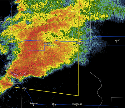
Radar at 4:34pm:
 We have a splitting supercell. The northern cell will produce large hail. The southern cell will produce large hail with the better chance of damaging winds. It should be especially monitored for a possible tornado.
ORIGINAL POSTING:
Entire Little Rock Metro is included. Radar at 5:20pm below:

Hail large than 1" in diameter and winds in excess of 60 mph are possible with this storm in the yellow polygon. Bring your car and lawn furniture indoors and gather up the children. Keep in mind a tornado watch is in effect. Be prepared to move to shelter.

Radar at 4:34pm:

ORIGINAL POSTING:
Entire Little Rock Metro is included. Radar at 5:20pm below:

Hail large than 1" in diameter and winds in excess of 60 mph are possible with this storm in the yellow polygon. Bring your car and lawn furniture indoors and gather up the children. Keep in mind a tornado watch is in effect. Be prepared to move to shelter.


Comments
Post a Comment