How Storm Chasing Made Commercial Aviation Safer
I just bumped this to the top because weather science may have prevented a plane crash this afternoon. See addition at the end of this posting. Weather science does it again!
ORIGINAL POSTING:
Aviation and storm chasing??!! Seems like an odd combination. Let me explain.
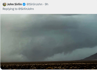
Yesterday, on Facebook, the delightfully named Amelia Rose Earhart, a pilot, posted the item below:
If you cannot read the words at the bottom, they say,
We flew West of a dry microburst yesterday and it was incredible to see the winds curl out as they impacted the ground. The dust that spread from the downdraft was incredible to see! It was gone as quickly as it arrived.
You know who discovered the "curl"? Yours truly! It was July, 1978, and my friend meteorologist Steve Amburn (now with the NWS Tulsa) and I were -- you guessed it -- storm chasing southeast of Wichita.
The year before, Dr. Ted Fujita of the University of Chicago hypothesized the existence of a type of storm that caused a "downburst" in a paper published in the journal Monthly Weather Review. To put it mildly, Fujita's hypothesis was met with skepticism.
Steve and I were southwest of Andover, Kansas, and we saw an unusual set of circumstances so I started taking photos. (If you want to learn the full story, you'll have to read Warnings). To our astonishment, the rain started curling. Here is one of the seven photos:
Steve and I looked at each other and said, "Have we just seen one of Fujita's downbursts?!" Turned out we had and that was confirmed by Dr. Fujita after I express-shipped the photos.
At that time, wind shear was the #1 cause of commercial airline crashes. It has now been 19 years since last occurred, thanks to Dr. Fujita, Dr. John McCarthy and many others. Thousands of lives have been saved by the elimination of these crashes.
Update: Wednesday, 2:38pm: Just retweeted by James Spann...
Translated it says, Birmingham Control Tower just issued a microburst alert for Runway 24. Aircraft 3 miles out on final approach can expect a 30 knot loss of airspeed (meaning a plane would lose lift then rapidly lose altitude). Another potential plane crash averted!
Here is a map of the winds near the airport (the runway is the thick orange line) two minutes before. The purple arrows show the diverging winds of the microburst.
So, even though meteorologists have "tamed" wind shear, the passengers will almost certainly never know what weather science just did for them.


LOL! Those passengers will simply blame the airline for another mis-explained delay.
ReplyDelete