Hurricane Odile Update: 10:30pm CDT
10:45pm CDT update via Twitter from a hotel in Cabo.
-- Original Posting --
I have plotted the current position (red) and my forecast position of the eye (orange) in about two hours.
Both Cabo San Lucas and San Jose del Cabo will be hard hit with a large storm surge. In both cities there will be structural damage with perhaps a higher surge at San Jose because of the shape of the coast (arrow). Wind gusts of 125 mph or higher are forecast. A storm chaser in Cabo says the wind sound recently went from a "whistle" to a roar which is indicative of the approach of a hurricane.
There may also be a storm surge (lesser intensity) at LaPaz.
Here is the satellite image from 10pm CDT.
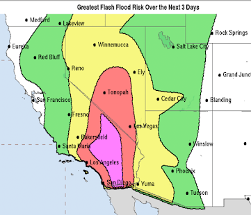
Important: There will likely be desert flooding in the Southwest USA, perhaps as early as tomorrow afternoon with it becoming more widespread the middle of the week. It also looks likely that some location (don't know where yet) in the Central third of the U.S. could have a heavy rain episode.


Comments
Post a Comment