Posts

Tuesday's Missed Tornado Warning in Kansas

Image
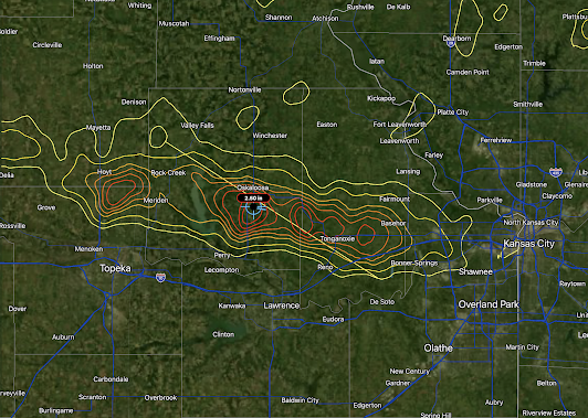
Greenwood County tornado damage, KWCH TV News It is not known which tornado produced this damage.  We often discuss tornadoes that were improperly warned by the National Weather Service (NWS).  We had a completely unwarned tornado in the Kansas Flint Hills region Tuesday morning but I don't fault the NWS for not anticipating it.  They found the tornado path's (tornado #2, yellow path) when looking for a tornado that occurred earlier  that morning in Greenwood County. The tornado in question was an EF-2, which is rated "strong" intensity.  As to why I don't fault the NWS, let's take a look at the radar data.  The tornado touched down at 7:34am. The radar image immediately below was one minute before the start of the tornado and there is nothing remotely tornadic in the immediate area (circle). The tornado has been on the ground for one minute at this point. Still, nothing. There is weak rotation to the SSW of the location but nothing that would say, "torn

Note to Readers...

After four straight days, I'm happy to report that no tornadoes are forecast to occur before the middle of next week. 

Big Climate Must Believe We are Really Gullible

Image
For more than a quarter-century, these utter hypocrites keep trotting out the, "we only X years to save the planet..." nonsense. Of course, almost none of these people (Al Gore, John Kerry, etc.) are scientists or even close to scientists.  In 2013, I published a post called " Tipsy From Tipping Points " that you may enjoy revisiting.  Global warming is a manageable problem that deserves serious solutions rather than this constant stream of hype, hypocrisy and nonsense. 

[Updated 7:20pm] Two Severe Thunderstorm Watches in Effect

Image
About 70,000 people are without power. Customers = homes + businesses.  Multiple tornadoes have been confirmed in western Illinois and eastern Missouri early this evening. A new tornado or severe thunderstorm watch has been issued. This severe thunderstorm watch is in effect until 8pm. Note that tornadoes, 2" hail and 70 mph thunderstorm-generated winds up to 70 mph.  Second severe thunderstorm watch. No tornadoes are forecast. 

The National Weather Service's Current System Outage and Why We Need a Natural Disaster Review Board

Image
Joplin, after the tornado We all remember the 2011 catastrophic Joplin Tornado and the loss of 161 lives — by far the worst single tornado disaster since the civilian tornado warning program began 1957. From 2000 to 2011, the National Weather Service (NWS) was making tremendous progress in warning of tornadoes. Tragically, the NWS and local emergency management during the hour before the tornado arrived did just about everything wrong .  Prior to Joplin, the NWS, on average, provided 13.3 minutes of advance notice and correctly warned of tornadoes 73.3% of the time. In 2007, they reached a superb 78% of the time.  For reasons that are not entirely clear,  the tornado warning program has suffered serious deterioration since 2011.  The NWS’s most recent figures reveal they correctly warn of tornadoes just 57% of the time (a 27% reduction) and, when a warning has been provided, it has dropped to 8 minutes of advance notice (a 40% reduction). NOAA has set a target of 72% of tornadoes to be

Today's Tornado Risk

Image
The area in brown has a significant risk of tornadoes. There is also a better than average chance of damaging thunderstorm-generated winds.  This hail forecast is the probability of 1" diameter hail or larger. The area in red has an enhanced risk  of large hail. The yellow area has a significant risk. Where the hatching exists, the hail could be 2" or larger.  I will update the forecast this afternoon. 

[Updated, 6:55am Thursday] What Actually Happened?

Image
The forecast was of excellent quality.  Hail up to baseball-sized fell. Congratulations, NWS SPC.  ----- NWS SPC just released this forecast valid until midnight.  The red outline is where hail, perhaps very large, is most likely.  Radar shows what will likely be the hailstorms forming near Manhattan.  9:27pm ----- The NWS SPC is forecasting large hail in Kansas tonight. Forecast valid till 7am. The is a significant risk of hail 1" in diameter in yellow. Where you see hatching, there is a risk of giant hail, 2" in diameter or larger.  With the benefit of the evening data from weather balloons, the HRRR model has changed its forecast. No thunderstorms in southern Kansas this evening.  Midnight: 4am Thursday: